Showing posts with label Google Maps. Show all posts

Tuesday, July 11, 2023

The Dumaguete Airport Road Bridge

I mentioned on one of my blogs that Google Maps Can Be So @#%$ing Lame. At that time, I had attempted to add a couple of local bridges to Google Maps only to be told that the edits could not be verified. As it turned out, those bridges were eventually added to the Map without my getting credit. At least I was finally able to upload some photos of the bridges.

Now today, I found myself in a part of Dumaguete where I had never ridden my bicycle, and came upon Dgte. Airport Road Bride. I took photos of the bridge and attempted to add its location. The edit was not accepted.

I don't understand how Google Maps can reject an edit when photographic proof is provided. At any rate, I'm posting the photos here. Maybe one day Google Maps will "aggregate its fecal material".


Tuesday, March 28, 2023

2,500 Miles


I mentioned in my blog post from Sunday, that during that morning bicycle ride, the odometer on my bicycle passed the 4,000 kilometer point. I also noted that when my odometer reached 4024 km that number would translate to 2,500 miles.

So, to commemorate that....um.....milestone, I'm posting a photo of the odometer at 4024 km and a photo of where I was when I reached that number. Metro Dumaguete College on E.J. Blanco Dr.


Sunday, February 5, 2023

The Cubiertos Volkswagen


I first posted photos of the VW Beetle that is located outside the Cubiertos Restaurant and Grill in Sibulan onto my sorryalltheclevernamesaretaken blog in October of 2018. At that time, the VW was painted a bronze color and was basically used as a large flower pot. (see photos at the above link).

In February of last year, I met with 3 American friends to have lunch at Cubiertos and discovered that the flowers had been removed from the trunk of the VW and the car had been repainted a canary yellow.

Cubiertos is located on the National Hwy. in Sibulan in an area where I do not normally ride my bicycle, so I only recently learned of the changes involving the Cubiertos VW when I happened to drive by in the car.

As can be seen in these new photos taken this morning, the VW is still the same canary yellow, but now sets atop the roof of the restaurant. I logged onto Google Maps in order to add these photo to the restaurant location on the map and I discovered that Cubiertos was not on Google Maps. I was sure I had seen it there previously. At any rate, I edited Google Maps and added the restaurant. It should show up in a few days.

Below are the photos I took this morning.


Sunday, July 17, 2022

Bicycle Ride to Calabnugan

A friend of mine recently posted onto Facebook a few photos he had taken from the Calabnugan bridge. Seeing his photos, I was reminded of some photos I had taken from the same bridge and had uploaded to Google Maps. I've ridden my bicycle a few times to the bridge, but it occurred to me that I had never crossed over the river at that point. I decided to remedy that.

I looked on Google Maps and saw that there were a number of places that I could photograph for the website. These included the Calabnugan elementary school, the Calabnugan Barangay hall, the Tsuri Cafe and Pis-An Store.

My original plan was to go out on my bike early Friday morning and take the photos. Unfortunately, I discovered that the rear tire on the bike was flat. There's a vulcanizing shop within walking distance of my house, so I removed the rear wheel and headed that way. The inner tube was patched and I walked back home.

I've always had somewhat of a difficult time taking off and putting back on the rear wheel; dealing with the derailleur has always been a hassle for me. By the time I managed to get the rear wheel on, I was too hot and sweaty to do the 11 km (to and from) ride to Calabnugan. I'd put that off until Saturday morning.

Going out Saturday, I noticed that the derailleur and gear cables were in need of adjustment. I believed, however, that I'd still be able to make the planned ride. I was mistaken. I was able to ride, but I was not able to switch into a full selection of gears and getting to Calabnugan was harder than it should have been.

I turned around before getting to the elementary school; I'd have to postpone the full ride until after I had the cables and derailleur adjusted. After arriving home, I caught my breath and rode to a bicycle repair shop in Sibulan.

So, Sunday morning, with the bicycle back in 100% running order, I managed to complete my planned ride to the Calabnugan elementary school and take the photos I wanted for Google maps.The photos below are only a small sample of the photos taken.


Monday, January 17, 2022

And it Comes Out Where?


If one travels along Motong Road from the Motong Brgy. Hall to the Morning Star Gas station, you'll run into Boni Catarata. Taking a right on Boni Catarata will take you to Rovira Drive. A left turn onto Rovira takes you to Brgy. Camanjac - a right turn takes you to Brgy. Pulantubig. Looking directly across Rovira, one sees an unnamed road. This road can be seen in the first photo of this blog post. In this post, I will refer to that road as "entrance X".

One day, my friend Ken R. and I were talking about entrance X (although we didn't call it that back then). Neither of us had traveled down that road and we were both mildly interested in where it might lead. I had my own theory about that.

My Theory

Although I may change up the route from time to time, my usual bike ride takes me along Dionesio Calbat. I'll turn right at the Tubtubon Brgy. Hall and head toward Rovira Drive at the old Alymae intersection. The road coming from Tubtubon ends at another unnamed road - left goes (after a fashion) to Rovira. I had hitherto never taken a right turn there - I had no reason to, but it was this right turn which I believed might come out at entrance X.


One morning, I decided to test my theory. It turns out that I was mistaken. Rather than take me to entrance X, the right turn ended in what can best be described as a pig trail. A path. One could, of course follow the path on foot, motorcycle or bicycle. I was not inclined to do so.

Yesterday, I decided to settle the question, once and for all. I would enter entrance X from Rovira and see where it takes me. It could very well end at a pig trail too.

Most of entrance X is a paved road, although it will convert to a gravel road in spots. That's par for the course here.


When I reached the end, I could not have been more surprised. It wasn't a surprise that the road would run into Capt. A Cornelia Rd., but I never suspected the road would end at the Xuekashi Motorparts store. Heck, I ride by there almost every day and never noticed a road directly across from the motor parts store. Well, live and learn.


Saturday, August 21, 2021

The Buñao Road


Prior to my 10K rides (one being accidental and the second being intentional ) I had never traveled along the Buñao road, so of course I had no photographs of any business on the road to upload to Google Maps. After yesterday's ride to and from the Calabnugan Bridge , I decided to remedy that.

The sky was a bit overcast as I left out this morning, but I was hopeful it wouldn't rain. I wasn't sure if I'd be up to a 10K ride today, so I decided to turn on to the Buñao road before, rather than after going down to Gas & Go. When I had finished taking the photos along the Buñao road, I felt I could be able to make it a 10K this morning, but the sound of thunder caused me to change my mind on that. Still, I still managed an 8.6 kilometer bicycle ride.

I took six photos. Unfortunately only four of those locations were already on Google Maps - Casa Bianca, Sisig Legend, Buñao Chapel and Negros Oriental Montessori International School. There are also places shown on Google Maps which I could not locate to photograph - Tattoo Shop in Dumaguete City: 3 Dots Tattoo being one example.


I'm including the two photos, which I could not post to Google Maps, into this blog post.


Friday, August 20, 2021

Calabnugan Bridge


Today, I'm indulging four of my hobbies - blogging - cycling - Google Maps and photography.

Before leaving the house this morning for my daily ride, I put my camera in my sling bag - I'll be taking it with me today. My destination will be the bridge crossing the Okoy river in Barangay Calabnugan.

According to Google Maps, the distance from my house to the bridge and back is 7.2 kilometers. I want to mention that there is a slight uphill grade going there - with, of course, a slight downhill grade coming back.

When I arrived at the bridge, I took a few photos. A couple of the photos show the view from the bridge. Not only will these photos appear in this blog post, but I'll upload them to Google Maps as well.


Friday, August 6, 2021

Post Correction


In an earlier post of this morning, documenting my bicycle ride to and from Mercury Drug in Sibulan, I had included a screen shot, taken from Google Maps, of the route taken.

However, after going back to the post, I noticed an error. The route shown on Google Maps has it going down Divina Gracia St. to the National Hwy., then taking a left on the Hwy. on to Mercury Drug. I did not notice the error when I originally published the post. I had actually turned left on Nillas St. before reaching the Hwy. Consequently, the distance shown is a little longer than the one I took on that ride. The total, round trip distance was 5.6 kilometers rather than the 6.4K originally stated.

In good conscience, I couldn't let that error stand. That's the reason behind this new post.

Friday, July 30, 2021

Accidental 10K


As I mentioned in Wednesday's blog post, I had a couple of options as to how to finish out this week's bicycling. I decided that I would take yesterday (Thursday) as a rest day, coming back to cycling on Friday and Saturday.

While resting Thursday, I thought about what I'd do today. One thing I decided on was to make changes in my use of the bicycle gears.

My bike has three gears on the front crank set and eight gears on the rear cassette. On the crank set, the smaller the gear, the easier it is to pedal - the larger gear adds more resistance. The gears on the rear cassette are opposite - the larger the gear, the easier to pedal. When I was riding on the Diversion Road I would stay in gear #1 on the crank set because of the slight incline and use a variety on the cassette on the way to Camanjac. Returning home along the Diversion Road, I would switch into #2 on the crank set because there was now a slight decline and I wanted more resistance.

As I began my new routine thru Tubtubon I found my use of the gears unsatisfactory. Most of this new route was flat enough where #2 on the crank set was fine, but when I'd change to #1 going up hill, the resistance would be way too loose. I decided that, starting today, I would keep the crank set in #2 the entire ride and strictly change gears on the cassette when needed. If having the front in #2 and the rear in a high gear while going uphill proved difficult, well, I'd have to soldier thru.

Knowing I'd be rested this morning, I wanted to do my best as far as distance was concerned. The minimum would be the 7 kilometer ride to and from the Gas & Go at Rovira Drive.

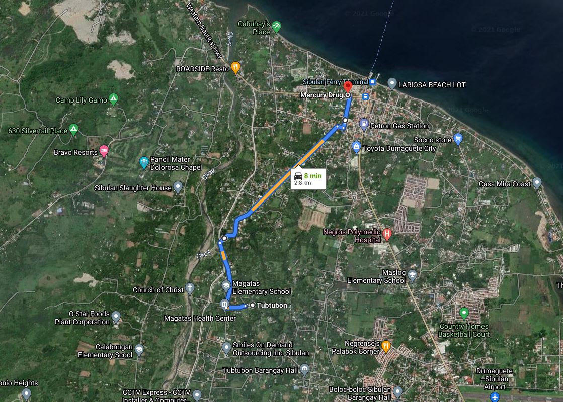
On the return ride from Gas & Go along Capt.A Cornelia Rd., there is a road that turns to the right - Buñao Rd. - According to Google Maps, there is a road that goes to the left from Buñao Rd. which connects with Dionesio Calbat. My plan was to take the right on Buñao Rd. then this left and back home via Dionesio Calbat. According to Google Maps, going this way would add 1.8 kilometers to my return ride. My total to and from Gas & Go would be about 8.8 kilometers.

However, this was a bit of a snag this morning. There was no turn to left!


I continued on to the National Hwy. I had two options at that point. Left onto the National Hwy to Dionesio Calbat or return to Capt.A Cornelia Rd. via Buñao Rd. I felt that going along the National Hwy. was an unsafe option, so it was back the way I came.

Needless to say, this addition to the ride this morning was quite an effort. When I made it home, I relaxed a bit before going online to Google Maps to calculate the added distance. Going back and forth on Buñao Rd. had added 2.8 kilometers to my ride, making this morning's ride 9.8 kilometers.......hammering hard on 10K.

It was an accidental 10K (more or less) and a very good ride. Add to this my new gearing policy, I had quite the workout this morning.

Saturday, July 24, 2021

Personal Best


It's been slightly over four months since I purchased my bicycle. I bought the bike a month before my 69th birthday, and I must admit, I found it difficult starting out.

I began my journey to increase my stamina by taking a daily bike ride along the Diversion Road in Sibulan. It certainly wasn't easy in the beginning, but I continued to ride four or five days a week, until I eventually managed to ride to the end of the road in Camanjac and back - a distance of 4 kilometers - regularly.

Looking to go on to a different level, I began, a few days ago biking along a different route past the barangay hall in Tubtubon.

This morning, I accomplished my personal best, by riding well past the barangay hall and on to the Gas and Go gas station on Rovira drive.


According to Google Maps, the distance there and back is 7 kilometers. Compared to my first ride on the day I purchased the bicycle, I view this as a major victory. Having reached this goal, I can see this route as my regular routine until I'm ready to jump to a 10K ride every morning.

Sunday, December 27, 2020

Sixteen Million Views


This past October, I mentioned on two of my blogs [robertsimms.blogspot.com/2020/10/fifteen-million and sorryalltheclevernamesaretaken.blogspot.com/2020/10/15-million-views] that the photos I've uploaded to Google Maps had received in excess of 15 million views. Now, in late December, I've learned that these photos have received more than 16 million views.

Naturally, I'm proud of this accomplishment.

I hadn't been checking the stats of late, so I don't know when the number had passed the 16 million mark. Of course, I have uploaded a few photos since October, though not enough to warrant this additional number of views.

I did notice that my photo of what was then known as Silliman University Anthropology Museum was the number one viewed photo in October and December. This photo has been my most viewed photo since, at least, 2018.

In October, the number two spot was held by Negros Oriental State University - Main Campus with St. Paul University Dumaguete in third. Now, the two schools have switched places.

Monday, October 19, 2020

Walking Along The Diversion Road


A couple of years ago, I drove to the end of the Diversion Road, and with the help of a mobile app, I was able to mark the location as "saved" when I'm signed into Google Maps. That was some time ago and I don't recall my motive for doing that at the time, but it has come in handy today.

As I mentioned in an earlier post, I like to take my morning walk to a location marked on the map ...... partly in order to measure the distance and partly to be able to have a screen shot of the route taken on my walk. Making a few minor alterations, I was able to document my walk today to where the Diversion Road dead ends. According to Google Maps, the distance, there and back is 4.2 km (2.6 miles). This is the same distance given by Google Maps to and from my house to the Camanjac Barangay hall. Looking at the maps, it's hard for me to believe Google Maps hasn't made a slight error one way or the other.

Just before the Magatas Barangay hall, there is a detour for the Diversion Road. Although the road continues on for two kilometers, after that point, there is no proper exit for the traffic going toward Dumaguete.

One notable difference in the two sections of the Diversion Road, is that in the section where there is less automobile and truck traffic, there are considerably more stray dogs lying in the middle of the road. Obviously, there is less chance of being hit by a car in the less traveled section.