Sunday, October 25, 2020

Three Versions of the Same Movie......


In 1933, Warner Brothers released the film The Mayor of Hell starring James Cagney.

The "Hell" referred to is a reform school run by a "brutal, heartless warden and his thuggish guards". Cagney takes over as deputy commissioner and reforms the reform school. Of course, things don't run smoothly, but Cagney succeeds in the end.

Evidently, Warner Brothers thought this was a winning formula for a movie and remade the film in 1938 as Crime School with Humphrey Bogart and the Dead End Kids. The plot isn't exactly the same - there are minor differences. Still, Bogart takes over and reforms the reform school. Interesting to note, one actor played in both films - George Offerman Jr.

In 1939, Warner Brothers wanted to make the movie once again - Hell's Kitchen.

The Dead End Kids return in this version with Crane Wilbur getting credit for writing the 2nd and 3rd versions. Versions 2 and 3 also have same producer and director.

Hell's Kitchen more closely follows the plot of the first film. However, the lead actor taking over to reform the school (Stanley Fields) is not romantically involved with the leading lady, as Cagney and Bogart were in their film versions. In Hell's Kitchen the romantic lead is taken over by a young Ronald Reagan who plays the nephew of Fields' character. 


Wednesday, October 21, 2020

Oh, How the Mighty Have Fallen


I thought things were rough in 2016 when I first posted (on another blog) how circumstances had forced James Bond to find employment driving a pedicab on the side.

Now, it looks as if the economic downturn, brought on by the pandemic has caused more difficulties for Mr. Bond.


Monday, October 19, 2020

Early Bogart

Last night, I watched two films featuring Humphrey Bogart from early in his career - from 1937  San Quentin  and  Swing Your Lady from 1938.

Starring with Bogart in San Quentin was Pat O'Brien and Ann Sheridan. This film is your run of the mill Bogart film from the late 30's - with Bogart as a tough guy who has trouble with the law. No surprises.

Of the two, I preferred Swing Your Lady although I'm sure to be the only person who thinks that way. 

According to wikipedia, Bogart considered his performance in the film the worst of his career and Swing Your Lady was listed in the 1978 book The Fifty Worst Films of All Time

It's not the sort of film you'd expect to see Bogart in. In some ways, the film brings to mind the Harold Lloyd film,  The Milky Way. Not exactly a screwball comedy.....but close. 


The film features Frank McHugh, Penny Singleton (with black hair), Allen Jenkins and Ronald Reagan in one of his earliest films.


Walking Along The Diversion Road


A couple of years ago, I drove to the end of the Diversion Road, and with the help of a mobile app, I was able to mark the location as "saved" when I'm signed into Google Maps. That was some time ago and I don't recall my motive for doing that at the time, but it has come in handy today.

As I mentioned in an earlier post, I like to take my morning walk to a location marked on the map ...... partly in order to measure the distance and partly to be able to have a screen shot of the route taken on my walk. Making a few minor alterations, I was able to document my walk today to where the Diversion Road dead ends. According to Google Maps, the distance, there and back is 4.2 km (2.6 miles). This is the same distance given by Google Maps to and from my house to the Camanjac Barangay hall. Looking at the maps, it's hard for me to believe Google Maps hasn't made a slight error one way or the other.
Just before the Magatas Barangay hall, there is a detour for the Diversion Road. Although the road continues on for two kilometers, after that point, there is no proper exit for the traffic going toward Dumaguete.

One notable difference in the two sections of the Diversion Road, is that in the section where there is less automobile and truck traffic, there are considerably more stray dogs lying in the middle of the road. Obviously, there is less chance of being hit by a car in the less traveled section.


Sunday, October 18, 2020

Fifteen Million


There was a time when I would regularly make note, on one of my other blogs ,the number of views the photographs I'd uploaded to Google Maps had received. With the creation of this blog, I last noted those numbers when the views reached Twelve Million.

Over the past few months, I've neglected mentioning, on either blog, the number of views received. However, I'm remedying that neglect today by making note of the current number of views my photos have received on Google Maps - at this date, slightly more than 15 Million views.

Unfortunately, these 15 million views only bring me bragging rights. I receive nothing from Google for uploading the photos- other than "points" as a local guide, which again, gives me nothing.

Saturday, October 17, 2020

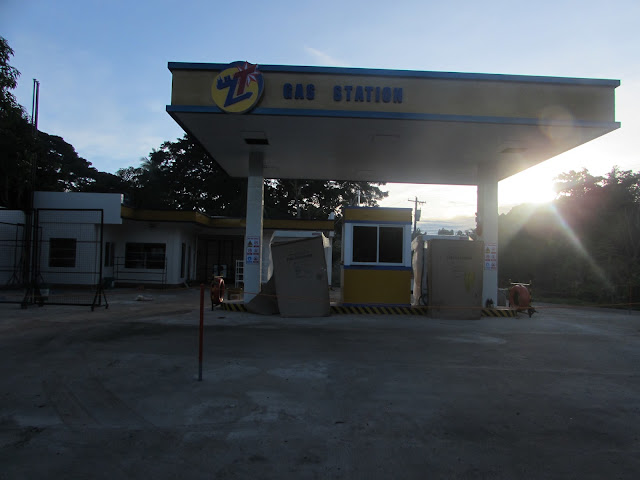
The ZT Gas Station


While on my daily walk this morning, I walked past a new gas station that, although not open for business, appears to be just about ready.

I took photos, of course, and was able to add the gas station to Google Maps. The three photos are also included here.


Walking to the Roadside Resto


It's become a habit of late, that when taking my morning walk, I'll choose a destination that is marked on Google Maps. Doing this, I can look at the map and get the distance from my house to the chosen location (and back).

Another reason I've started walking to a spot located on Google Maps is that I'm able to get a screen shot of the route.

This morning, I decided to walk to and from the Roadside Resto In Sibulan , a total distance of 5.2 km (3.2 miles). That's quite a walk for an old man.


Friday, October 16, 2020

You Call This a Road?


One topic which I seem to write about most on this blog is my daily, morning walk. Lately, my destination has been to the Tubtubon Barangay hall and back.

According to Google Maps, there are two different routes from my house to the Barangay hall; one shown in blue dots and the second, longer route shown as a gray line. When walking to the Tubtubon Barangay hall, I've always taken the "blue dot route". The distance there and back walking that route is 3.2 km (1.99 miles).

Until recently, I wasn't even aware of the 2nd route. As it turns out, that route goes by the Suplared Gamefarm, although I had no idea where it comes out onto the Camanjac/Magatas road.

This morning, I decided to walk to the barangay hall by way of the "blue dot route" and take the gray colored route on the way home. This would make the total distance 3.7 km (2.3 miles).

The road going to Suplared Gamefarm from Dionesio Calbat Road starts out as a paved road, though not as wide as Dionesio Calbat. The pavement doesn't continue long. A few meters before Suplared Gamefarm the road becomes gravel. It doesn't stay gravel very long. It eventually becomes a dirt road.

Actually, as these photos show, calling it a road may be a bit of an over statement.

As I said, walking to the Tubtubon Barangay hall and back by my normal route is 3.2 km (1.99 miles). If I want to go farther than 2 miles, the walk to the Camanjac Barangay hall and back is 4.2 km (2.6 miles).

The route I took this morning splits the difference, but I wouldn't want to walk that way on a morning, like today, which followed a rainy night.


You Can't Post This

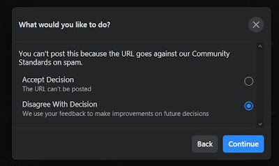
Since the first week of April, this year, my blog, sorryalltheclevernamesaretaken, has been banned from Facebook. I can't post links to that blog on my Facebook page - I can't even send a link to the blog on Facebook Messenger.

I will try to post links from time to time, but the links are always blocked. I'm told that it's because the blog is a "spam site". That's not true, of course. I've disagreed with the decision, but communicating with Facebook is like beating a dead horse.

I tried to post a link to the blog this morning -[My Love/Hate Relationship With The Internet ] with no success.

Screen shots of the response I received are shown below.


Triple Y Gas Station


Yesterday, while walking to the Camanjac Barangay hall, I passed a new gasoline station located where Rovira Drive intersects the road going into Magatas - the Triple Y Gas Station.

As I walked by, I took a few photos. When I returned home, I added the location (and photos) of the gas station to Google Maps.

A map showing the location of the new gas staion can be found below, following the photographs.


Thursday, October 15, 2020

Saint Vicente Ferrer Parish Church


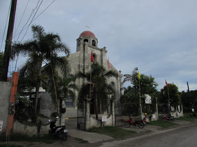
This morning, I took an alternate route on my walk - this time to the Camanjac Barangay Hall. Of course, on the way, I walked past the Saint Vicente Ferrer Parish Church. I couldn't resist taking a few photos to upload onto Google Maps.

 In addition to these five photos, I had previously uploaded 15 photos that I'd taken of the church - inside and outside, as well.


Camanjac Barangay Hall


I've mentioned in an earlier blog post - [Tubtubon Barangay Hall ]- that my normal morning exercise consists of walking to the Tubtubon Barangay hall and back. According to Google Maps, the total distance from my house to the hall and back is 3.2 km (1.99 miles). I've been thinking lately of walking instead to the Camanjac Barangay hall. I put thoughts into action and walked there this morning.

After I returned home, I checked the map and learned the distance from my place to the Camanjac Barangay hall and back is 4.2 km (2.6 miles). Naturally, I took a screen shot of the route.

Of course, I took a couple of photographs of the barangay hall....after all, what's a blog post without photos?

I also uploaded the photos to Google maps.


Wednesday, October 14, 2020

Suplared Gamefarm


In yesterday's blog post [Tubtubon Barangay Hall ] I included a screen shot of the route I take on my walk from my house to the Brgy. hall, according to Google Maps. On the screenshot, my route is shown with blue dots. There's an alternate (longer) route shown in gray, of which I was previously unaware.

While walking this morning, I took notice of the road - paved, but not as wide as the main road. At the intersection, there is a sign directing you to Suplared Gamefarm. Although I wasn't up to walking the entire road to where it intersects the Magatas/Camanjac road, I wanted to take a detour along the road, out of curiosity.

I walked until I came upon the game farm. I had no way of measuring the distance, but it seemed to me that the distance from the game farm to the road where I started, is about the same as from that intersection to the Tubtubon Barangay hall. My walk this morning should be approximately the same.....about 2 miles.

Naturally, I took photos. I knew the photos would be posted here, but I thought there might be the off chance I could upload the photos onto Google Maps.

Unfortunately, the Suplared Gamefarm hasn't, as yet been added to Google Maps. I thought of adding the farm myself, but I'm not 100% certain of it's exact location on the map. I'll leave that for another day.